Land Use and
Vegetation History
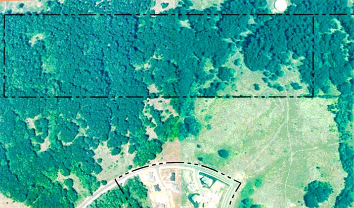
The Brandis property contains some of the last
vestiges of
native savannah oak and other prairie plants in the Dixon Creek basin,
due in
part to its hilly nature and distance from past residential
developments and
transportation corridors. Prior to white
settlement the property was maintained with regular broadcast burning
by local
Chepenafa Indian families, probably for the production of nuts, bulbs,
roots,
fruits, and seeds, among other purposes.
Beginning in the late 1840s and continuing until the 1950s, the
land was
owned by individuals or families who used it primarily for pasturage
(see
Appendix D). From that time until the
present the land has been mostly fallow, becoming dominated by invasive
Douglas-fir trees and Brachypodium grass during the last few decades. There is little evidence of past construction
on the site, other than a buried city waterline, a number of unofficial
and
poorly maintained farm roads and trails, old fenceline segments around
the
perimeter, and some scattered lumber that may have been a tree house or
lean-to.
Precontact
time
During the past several ice ages, no glacier is
known to
have entered the Willamette Valley from western Washington
to the north, or from the Cascade Mountains
to
the east. Marys Peak,
the highest point to the west, is only 4,000 feet in elevation and
probably has
experienced little, if any, glaciation during the millions of years of
its
existence. Likewise, the series of
catastrophic Bretz floods that repeatedly filled the Willamette Valley
with water, rocks, ice, and mud between 15,000 years ago and 12,800
years ago,
occurred at lower elevations and did not directly affect animals and
vegetation
at the project site. In addition, there
have been no volcanic eruptions in the area for millions of years, so
local
plant populations have not been affected by that means, either. Native plants have likely persisted in this
location through several ice ages--affected principally by wind, fire,
and
climate--until the arrival of people (and daily fire) at some time more
than 10,000
years ago.
This site apparently has a long
history--perhaps millions of
years--of serving as a refugium for native plants during times of
catastrophic
changes in climate, geology, and--in more recent times--human use, and
culture. During the past 10,000 years
both human and wildlife populations have benefited from stable patterns
of
diverse native food plants cultivated and harvested throughout the
Willamette
Valley; likely including Dixon Creek basin lands as well.
For those reasons, among others, it is an
excellent candidate to continue serving as a native plant refugium into
the
foreseeable future (at least for some species), and with human users
and
managers as a necessary component.
Historical
Time
The written history of north Benton
County, including the project
area,
can be said to have begun with the preserved journals of David Douglas
and
Alexander Roderick McLeod, who pioneered a Hudson's Bay Company (HBC) pack trail
through
the area during the first week of October, 1826. Many
individual oak trees, camas patches, and
other native plant populations noted by Douglas and McLeod have
continued to
persist in the environment to this time, forming a significant cultural
bridge
from precontact time to the present.
California condors, grizzly bears, and white-tail deer have
disappeared
from the environment since being noted by the early journalists, as has
nearly
the entire native oak savannah that was home to these animals.
It is very likely that the populations
of people noted by
Douglas and McLeod in the Willamette
Valley during the
1820s
was only a small fraction of the numbers that had lived here in the
1770s and
in earlier times. The principal reason
for the decimated populations was disease.
Native people had little or no immunity to the variety of
diseases
introduced by European, American, and African sailors in the 1770s and
1780s
and died by the thousands when they were exposed to small pox, malaria,
the
flu, and other illnesses common to the new visitors.
In 1788, Robert Haswell noted the appearance
of smallpox scars on Indians he encountered off the Oregon Coast; less
than 70
miles due west of the property and nearly 40 years before the arrival
of HBC
horses and mules at Dixon Creek. In
1805, Lewis & Clark noted abandoned communities and a pockmarked
individual
that had survived a small pox epidemic that had occurred about 20 years
before
their arrival (ca. 1775). Lewis and
Clark's observations took place about 70 miles due north of the project
area,
and about 20 years before the arrival of the HBC.
In October, 1826, Douglas noted several
Kalapuyans (probably
Luckiamutes) in the Berry Creek area of southern Polk County "gleaning
a
miserable existence" by digging camas bulbs in an area surrounded by
miles
of burned prairie and groves of savannah oak trees.
Based on significant archaeological data and
other considerations, these were likely the devastated remnants of a
large,
stable community once based in the immediate vicinity--but which had
been lost
to epidemic disease. The evidence for
the Dixon Creek basin is similar; that it had once served as a major
source of
camas for a Chepenafa community or campground located in the vicinity
of
present-day 29th Street,
and for a much larger community based near the mouth of the Marys River. While
flatlands remaining from Bretz flood
deposits were largely dedicated to camas production, hillsides were
major sources of strawberries, acorns, roots,
bulbs, and seeds; likely including tarweed seeds roasted on the stalk
in late
summer or early fall.
The transition from ownership and management of the Dixon
Creek basin by Chepenafa Kalapuyans began gradually with the 1826 HBC
contacts,
and ended abruptly in 1846 with the arrival and private property claims
of
white American immigrants, most notably the Mulkey family (see Appendix
D). The
new settlers brought hogs, cattle, horses, chickens, and sheep with
them, and
began to aggressively use the former root and bulb fields, nut
orchards, berry
patches, and prairie lands to pasture their herds and flocks. Indian trails leading to the project area
were quickly converted to farm use as a method of herding animals from
one
pasture to another, or to and from markets stretching from northern California to SW Washington.
This abrupt change in land use--from centuries
of regular burning and tillage to intensive grazing by domestic animals--continued
for about 100 years, until sometime after World War II.
By the mid-1950s, most grazing in the Dixon Creek basin had been
halted and the land began to be used primarily for specialized farming and
housing developments (see Appendix D). After grazing was stopped, the project area became fallow
and began to be populated with oak saplings and invasive Douglas-fir seedlings.
The trees were soon followed by Brachypodium in the shaded understory
and began displacing the remaining native shrubs, forbs, and grasses that
had persisted through long-term pasturage.
© 2005 by
Oregon Websites and Watersheds Project, Inc.