Part 2. Historical Accounts, 1826 - 1875
3. William T’Vault, Silas Casey, August V. Kautz & John Evans Expeditions Eastward: 1851 - 1856
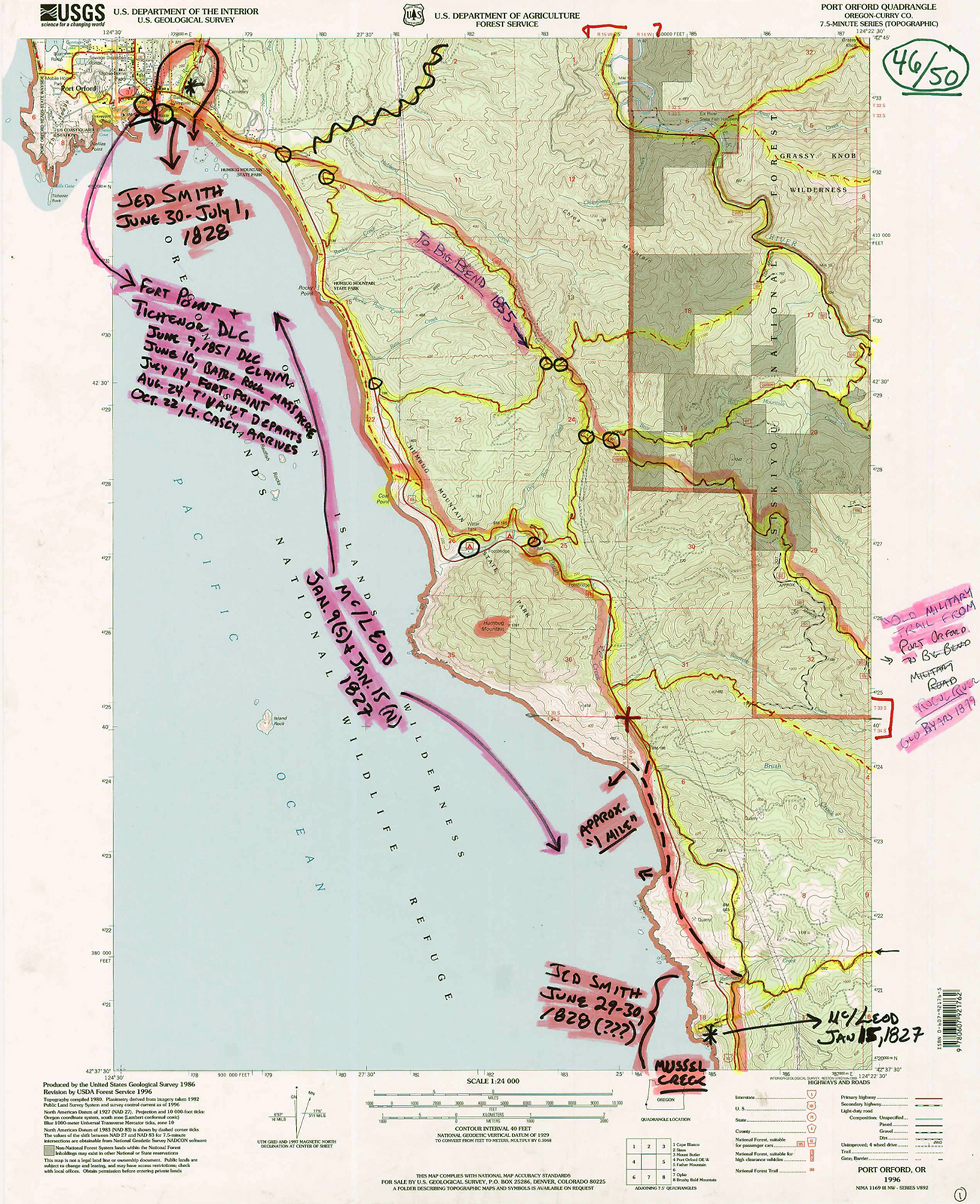
In the early 1850s there were two expeditions that took place within the study area that have each been associated with mystery for more than 150 years. Both trails begin at Port Orford and both reach the South Fork of the Coquille. Both expeditions may have used nearly the same route between those locations, although probably not.
The first mystery concerns the route taken by William T’Vault, under orders from William Tichenor, in an effort to connect a trade route between Port Orford and the portion of the “Oregon Trail” route approximated by the location of I-5 through Douglas County today. T’Vault’s expedition began with him getting lost and losing most of his horses, equipment, and men before being attacked by Indians on the mainstem Coquille River; in which five of his companions were killed. T’Vault and one survivor, Gilbert Brush, traveled south by foot to Port Orford. The two other survivors, Loren Williams and Cyrus Hedden, made their way north to the Umpqua River and safety.
A few months later, Lt. Col. Casey was sent to the Coquille River and killed a number of Indians near present-day Hoffmans, in large part as retribution for the T’Vault attack. He also established an official Army camp at the mouth of the Coquille River, helped establish Fort Orford, and improved the pack trail from the new Fort to the new camp into a “military road” capable of transporting heavy equipment and river boats (Vol. II, Part 1.3).
Five years later, near the conclusion of the Rogue River Indian Wars, Dr. John Evans followed an established military trail that may have closely followed T’Vault’s route. The mystery with Evans is not where he may have gone (that question has been carefully researched for nearly 80 years), however, but what he found during his travels – supposedly, a massive meteorite on “Bald Mountain” said to be worth tens of thousands or millions of dollars (Peterson and Powers 1952: 504-505).
Where T’Vault went, and where Evan’s meteorite (if it actually exists) is located, remain mysteries to this time. Records surrounding Casey’s well documented expedition may contain clues to both. The story, though, begins with the “Battle Rock Massacre” in which an estimated 25 Indian men were killed, just a few months before the beginnings of first T’Vault’s, and then Casey’s, expeditions from the same Battle Rock location.
Battle Rock Massacre (June 10 – July 2, 1851)
On June 9, 1851, William Tichenor landed his ship at present-day Port Orford, staying just long enough to establish a Donation Land Claim (said to be the first in Curry County) and to leave a crew of nine men behind, with promises of returning in 14 days with additional men and supplies (Dodge 1898: 22-24). The men camped out on a large rock with a single trail access to the beach. They had a supply of arms and ammunition and a cannon that they loaded and aimed down the trail. The following day the cannon was discharged into a group of local Indians headed up the trail, instantly killing a large number of them. Others were shot with guns. None of the crew were killed and only two were injured, but they decided to leave the rock and head north for safety when Tichenor had not returned as planned, 14 days later.
The ship “Columbia” landed at Port Orford in advance of Tichenor, but after the men had left, and it was assumed that they had been killed by the local Indians. This news was carried to San Francisco and Portland (Dodge 1898: 23). Instead, the men had safely worked their way north to the Coquille River, then Coos Bay, and ending at the white settlements on the Umpqua. The story of the men’s encounter and escape has been widely reported – most notably by John M. Kirkpatrick, the leader of the crew (Dodge 1898: 33-50) – and the scene of their “battle” has been named Battle Rock since that time (Victor 1894: 280-282; Beckham and Minor 1980: 120-121; McArthur 1982: 45; Hall 1995: 17-18; Schwartz 1997: 33-36; Tveskov 2000: 388-391; Zybach 2012: 65-68).
The story of the men’s travels from Battle Rock to Coos Bay in June 1851 is the first historical account of the use of that route since Jedediah Smith and Harrison Rogers had crossed the same landscape in July 1828 – 23 years earlier. The very next account would only be a few months later, in September, when a naked William T’Vault and his severely wounded companion traveled from the Coquille River to Port Orford, and their two fellow surviving expedition members traveled from the same location on the Coquille, north to Coos Bay.
William T’Vault Expedition (July 26 – November 4, 1851)
After helping establish “Fort Point,” upon his return to Port Orford, William Tichenor sailed to Portland, Oregon, where he filed a Donation Land Claim on his new Port Orford holdings in Oregon City, and enlisted several men to help develop his new land holding. He also “purchased six horses, some swine, and engaged a Mr. T’Vault who had been recommended highly to me by Col. Phil. Kearney” (Dodge 1898: 24). Tichenor then returned to Port Orford, along with additional military personnel and supplies. In his account of subsequent events, he wrote:
| A party under T’Vault had been sent with the horses to view out and cut a trail from Port Orford connecting with the Oregon trail; another under Nolan for a similar purpose. The latter had been instructed by me to ascend to the south of the Sugar Loaf Peak (“Humbug Mountain”) on the southwest of the roadstead, believing that to be the terminus of the great dividing range of mountains leading to the far interior, which has since proved to be such (Dodge 1898: 25). |
Nolan soon returned to Port Orford, unable to find his way. T’Vault ended up getting famously lost during his assignment, losing his horses, several of his men and most of his clothing and supplies before ending up in a canoe with some Indians and the remainder of his men, heading downstream on the Coquille River. On September 14, 1851, somewhere between present-day Coquille (according to Casey: November 9) and present-day Bandon (most other sources), T’Vault and his men were attacked, with five men being killed. T’Vault and Gilbert Brush (who was partially scalped) escaped safely back to Port Orford, while Loren L. Williams and Cyrus Hedden escaped northward to the Umpqua River (Victor 1894: 282-285; Dodge 1898: 25-28; Beckham and Minor 1980: 121, 140, 223; Hall 1995: 18-21; Schwartz 1997: 40-41; Tveskov 2000: 391-406). Hedden was also a participant and survivor of the Battle Rock massacre, but it is Williams’ account that has carried through to the present time.
Dodge (1898: 88) claimed to have an extended account of Williams' experiences with T'Vault on this expedition, "but owing to its length we have deemed it advisable to reserve that brilliant and romantic story for the second volume of this history." A second volume was never compiled by Dodge, but a copy of Williams' account apparently was published elsewhere, nearly 100 years later (Mark Tveskov, personal correspondence: 2011). Schwartz (1997: 41) references both men, but only provides a citation for Williams (ibid.: 277), which may be the same as referenced by Dodge: Ms. P-A 77, Bancroft Library, at UC Berkeley. Schwartz (1997: 277) also cites three "Alta California" editions of August 26, September 18, and December 14, 1851 as providing additional information regarding this event. Copies of these articles should also be found at Bancroft Library and/or may be available online. [Note: It is possible that Loren L. Williams later became a GLO Surveyor who worked – and probably lived – in the study area (e.g., Vol. II, Part 2.7: Flint & Williams 1871; Flint & Williams 1872). If so, that would add credibility to his written statements regarding numbers and geographical locations.]
Tichenor later wrote of T’Vault’s route (Dodge 1898: 25):
| Little of mountaineer skill was ever used or exhibited in their devious wandering. Mountain ridges were not followed or regarded. Immense gorges were plunged into without apparent hesitation. All the animals had to be abandoned, everything was disposed of as far as possible to enable them to travel or wander. |
Tichenor also claimed that during the following year, 1852, Lieut. Stoneman (who served under Col. Casey) "with his party of explorers, traced their [T'Vault expedition’s] trail, as shown by the cuttings, and found more evidence of insanity than rationality” (Dodge 1898: 25) -- if so, then perhaps a record of Stoneman’s report on his findings may still exist and help place a clearer light on T’Vault’s travels.
In addition, and also according to Tichenor, T’Vault “finally reached a point on the South Fork of the Coquille river, near which camp a depot was established the following spring [1853?], by Company C., First Dragoons, under Col. A.[ndrew] J.[ackson] Smith" (Dodge 1898: 25). Again, if this location has been mapped, or is otherwise described in an official report, correspondence, or a journal, then additional insight may be gained regarding T’Vault’s wanderings with the discovery and use of such information.
Lt. Col. Silas Casey Expedition (October 22 – November 22, 1851)
Lt. Col. Silas Casey of the US Army was assigned to punish the Coquille Indians responsible for the killings of T’Vault’s men, and arrived in Port Orford on October 22, 1851 to undertake this mission (Vol. II, Part 1.3). He and his men relocated to the Coquille River, setting up two camps, and on November 22, 1851 attacked and killed an estimated 15 Indians at the confluence of the Middle Fork and South Fork of the river. They also destroyed numerous canoes, homes, and several tons of salmon during this attack.
Of some interest is Casey’s awareness that his actions had more purpose than simple retribution. On November 9, 1851, reporting from the mouth of the Coquille River, he observed: “Inasmuch as there is an extensive farming country in the vicinity of Port Orford, extending to, and up this river, which if an adequate protection was afforded, would I think speedily settle.” On November 11, and from the same location, he added to that thought: “I consider it expedient to make a reservation at once, for by the Oregon land bill, some person would be sure to lay their claim.”
Lt. Kautz’ Military Expedition (October 8 – October 31, 1855)
In early October, probably the 8th or 10th, 1855, Lt. August V. Kautz set out from Fort Orford to make an examination of a proposed route for a military wagon road from that place to a juncture with the Oregon Trail, at some point in the vicinity of Fort Lane and Jacksonville. When he reached Big Bend on the Rogue River, he found the immigrant settlers in much alarm at a threatened attack from Indians on Applegate River, and he returned to the fort for a larger supply of arms and ammunition, to better prepare himself in case of an hostile attack.
According to Dr. Rodney Glisan, who assumed Kautz’ command at Fort Orford in Kautz’ absence:
| Lieutenant August Valentine Kautz, Fourth Infantry, who left here with ten men about eight days ago, to survey a road between this place and Fort Lane, returned last night about twelve o’clock to get arms and ammunition for his party. He reports that on reaching the big bend of Rogue River, forty-five miles from Fort Orford, he found the settlers making port-holes in their houses, preparatory to an attack from the Indians of upper Rogue River valley. He learned from them that being advised by some friendly Indians to leave the place, as the tribes above there were hostile, but not believing the reports they started up the river to ascertain the truth of the matter. On arriving in sight of a trader's establishment they saw the building in flames, and the Indians in a war dance around it and that they were further told by friendly Indians that all the tribes in upper Rogue River valley had united in war against the whites. This report, together with those received from Jacksonville last mail of the disaffection of the Indians in that region in consequence of the hanging of several of their head men at Yreka for murder, indicates that trouble is brewing in lower Oregon also. These Indians had been arrested by the United States troops at Fort Lane, and turned over to the civil authorities of California, who, it is presumed, gave them a fair trial. (Zybach 2012: 84). |
When Kautz returned to his reconnaissance project, he was attacked by Indians near Grave Creek, from where he and his men escaped to Fort Lane and reported on the location of the attack. Army and Volunteer forces were then assembled and a major assault made upon the Indians over a two-day period on Hungry Hill, above Grave Creek, with seven fatalities among the US troupes on October 31. Captain Thomas Cram, who had been stationed at Fort Lane, then reported to Congress (Zybach 2012: 85).
From my own reconnaissance in this district of Southern Oregon, and other sources of information, I think the best system of roads that can be opened in order to bring the Rogue river, the Coquille, and the Umpqua valleys into communication with a sea-port would be -- 1. To open a road in direct route seen on map No. 10, from Port Orford to the Oregon trail. 2. To open one from Cape Blanco to the navigable part of the Coquille; also one from the head of the navigable part of this river, following the middle fork, to the Umpqua valley. With such a system well executed these secluded valleys could avail themselves of Port Orford, as there is already by nature a good wagon road from this to Cape Blanco. |
Dr. Evans’ Geological Expedition (July 14 – July 23, 1856)
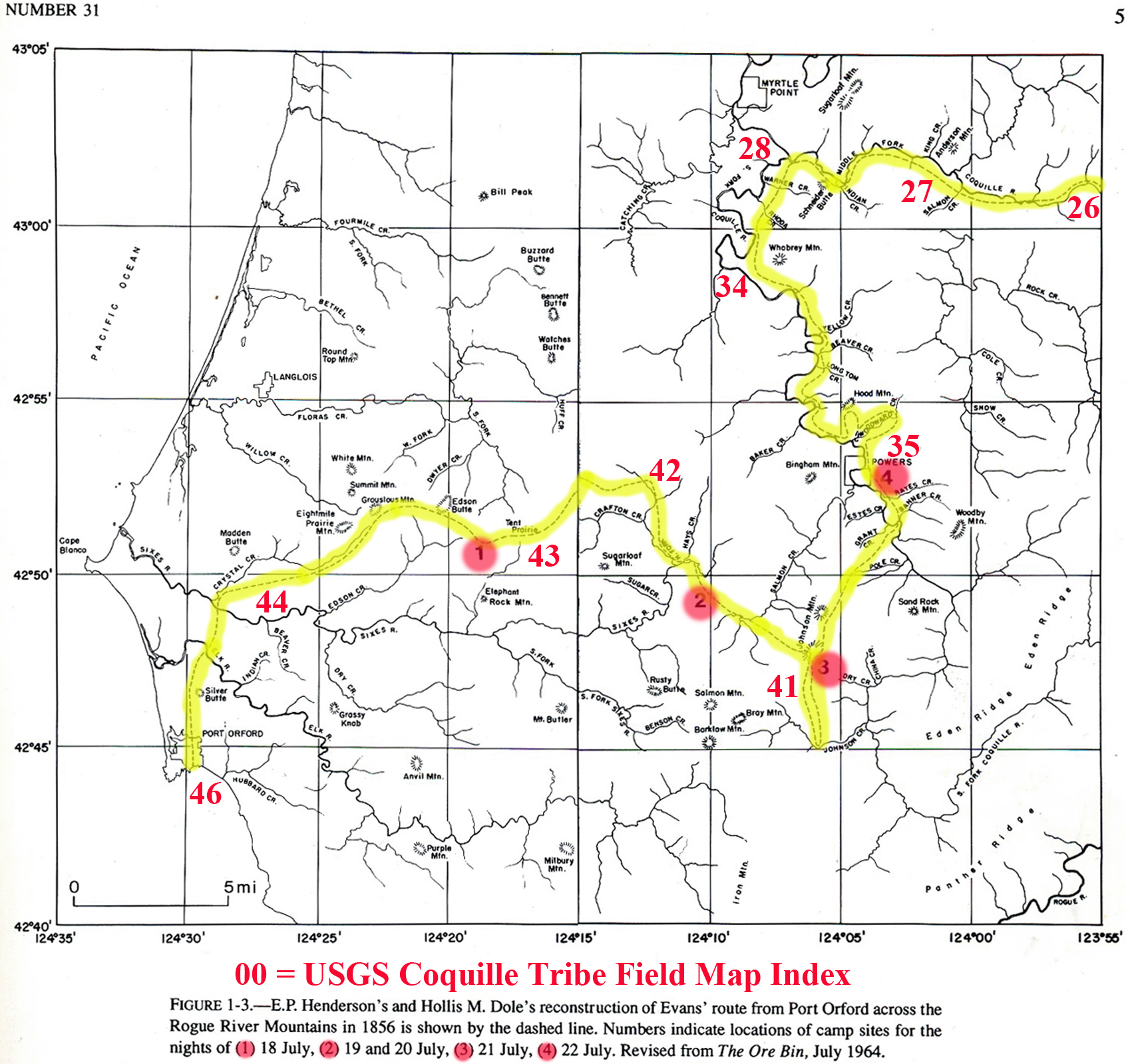
Dr. John Evans, United States Geologist for Oregon, arrived in Port Orford by ship on July 14, 1856 for the purpose of conducting a “geological examination of the vicinity” (Glisan 1874: 351). Fig. 9 shows the route of his travels eastward, during which he claimed to have discovered a giant, incredibly valuable meteorite, stuck in the ground near the summit of “Bald Mountain.”
Beginning on July 18, 1856, Evans began a one-week trip over the established pack trails from Port Orford to Johnson Mountain; from there, south to the mines on Johnson Creek; and then to the Umpqua Valley by way of Enchanted Prairie and Camas Valley (Beckham and Minor 1980: 221-222). The USGS quadrangle numbers given on Fig. 9 (26, 27, 28, 34, 35, 41, 42, 43, 44, 46) are individually described in Vol. II, Part 2.2, and the landmark names are listed in Vol. II, Part 2.5.
Evans maintained a journal of his travels, including detailed descriptions of his route and campsites, but there is no mention of a meteorite in those pages. A few years later, though, while in Washington, DC for the purpose of lobbying Congress to obtain funding for a return venture to Oregon, he claimed to have found a massive meteorite in the vicinity of Johnson Mountain: his description of which has been estimated at various times to potentially be worth tens of thousands – or even millions – of dollars (Peterson and Powers 1952: 504-505).
Evans died suddenly at the outbreak of the Civil War, before funding could be obtained to finance a return visit to the site of his supposed discovery. News of the discovery, however, when later coupled with the availability of Evans’ journal from the Smithsonian Institute archives, caused numerous search parties to form over the next 150 years in attempt to follow Evan’s route and rediscover the so-called “Port Orford Meteorite.” Subsequent research strongly suggested that Evan’s was perpetrating a hoax with the meteorite story due to a need to pay pressing debts -- yet efforts to both prove and discredit his story have led directly to detailed field and documentary analysis of his claims, route, and campsite locations (including maps) that were subsequently published in professional and academic journals (Clarke 1993; Henderson and Dole 1964: 113-130; Plotkin 1993: 1-24; Zybach 2012: 231-250).
Fig. 9. Dr. Evans’ Journal: Port Orford Trail Research, 1934 and 1992.
![]()