Part 2. Historical Accounts, 1826 - 1875
6. The Coos Bay Military Wagon Road, 1869 - 1875
The “Coos Bay Military Wagon Road” (Walling 1884: 486-487; Dodge 1898: 447; Peterson and Powers 1952: 54-55, 74-78, 121-122, 138, 239, 476-477, 482-483; Beckham 1997; Douthit 1986: 94-100; Zybach and Wasson 2009), or as it was more generally known, the Coos Bay Wagon Road (CBWR) was created by an Act of Congress on March 3, 1869, for the purpose of getting farm and manufacturing products from Roseburg and the Umpqua Valley to the deepwater port at Coos Bay. Its route, for most of its length, followed the East Fork of the Coquille; the same approximate route taken by McLeod when he traveled from the Coquille River to Umpqua Valley in February 1827. No Donation Land Claims were established in the East Fork Valley, although a few settlers tried to establish farms in the Fairview area in the early 1860s. These farms were unsuccessful, though, and during much of the 1850s and 1860s the area was populated by Indian families trying to avoid being killed or sent to a reservation by the new imigrants. Among the first historical accounts of anyone using this route after McLeod was the Josh Wright expedition in May 1867, more than 40 years later.
Among the CBWR Bill’s six sections were: 2) the lands could be disposed of for no other purpose than road construction, and the finished road would be a public highway, free from tolls or other charges for its use; 3) the road would be constructed to such width, grade, and with such bridges to State standards needed to permit regular wagon transport; and 6) the surveyor general of Oregon was instructed to survey the lands at “the earliest practical period” so that the legislation could be carried forward (Beckham 1997: 5-6).
Construction of the road began in April 1870, and was completed by 1874. The politics, construction schedule, investment history, and other details regarding the social and economic development of the CBWR are covered in the texts already cited – most notably Beckham (1997) and Peterson and Powers (1952). The general construction, use, and decline of the history of the CBWR can be roughly approximated in the history of the post offices for the small communities that came into being during its development: post offices were established at Fairview on May 7, 1873; Sitkum, May 9, 1873; Coos City, June 25, 1873; Dora, August 10, 1874; and Sumner, September 18, 1874; Reston, August 25, 1890; and McKinley, July 27, 1897. These same post offices were closed during the following years: Coos City, 1884; Fairview, 1913; Reston, 1934; Dora, 1939; McKinley, 1954; Sumner, 1955; and Sitkum, 1963 (McArthur 1982).
Joshua Wright Expedition (May 21-30, 1867)
During the course of research, Scott Byram came across a letter published in a Roseburg newspaper in 1867 by Joshua Wright (Wright 1867). Wright’s letter, titled “Road to Coos Bay,” was published in the Roseburg Ensign on June 18, and detailed a trip with Alva Harry (perhaps the troupe’s leader, Dodge 1898: 172-173), Horace Brewster, and three other men, that began on May 21, 1867. This trip followed Brewster’s earlier unsuccessful effort to find an overland passage between Coos Bay and Roseburg by traveling from west to east (e.g., Dodge 1898: 170).
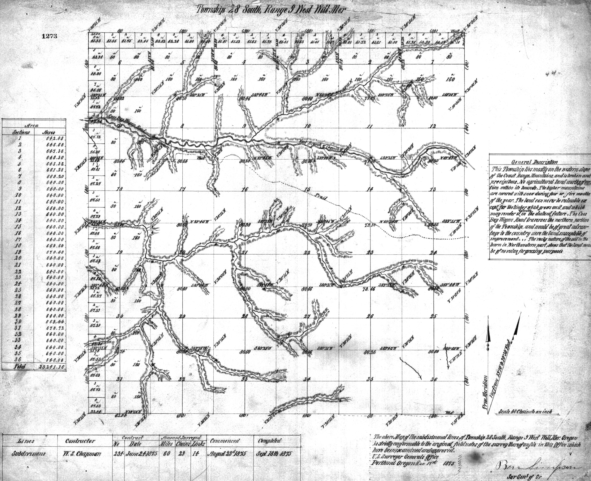
The expedition began its journey at Weekly’s Mill (present-day Reston). They then proceeded “around a high peak,” which may have been Kenyon Mountain -- aka “Signal Tree” or “Weekly Mountain” (Beckham 1997: 17) -- until they reached “a low gap in the Coast range” before heading west “down a long ridge, on which we soon struck a dim Indian trail.” This is quite possibly the same ridgeline “Trail” between Camas Creek and East Fork Coquille shown on the 1875 GLO map of Tsp. 28 S., Rng. 9 W. (Zybach and Wasson 2009: 24-25).
| Here we found a timbered valley about five miles long by from a half to a mile in width, and discovered six Indian houses. The occupants had evidently left them in a hurry, no doubt alarmed at our approach, and had taken most of their plunder with them, leaving among other things a very nice dress, several bed ticks and quilts (Wright 1867). |
The expedition then followed the East Fork to the west for about two miles “when we came to extensive bottom lands of the most fertile quality.” They then traveled about four more miles “through the bottom” and set up camp. Wright noted that the bottomlands were “covered with maple and myrtle timber with some small clumps of hazel.” The camp must have been near present-day Dora, because Wright notes that the river changed course to the southwest from their location, and that one of their party followed it down “some three miles” and that “the bottoms extended still further down, probably to the main river” (Zybach and Wasson 2009: 25). Wright also reported that: “We found more Indian houses and a grindstone.”
The next day the group traveled west “across a range of low hills” to “one of the tributaries” [probably Middle Creek, near present-day McKinley] of the North Fork Coquille, where “we found good bottom land, and a large band of wild cattle” that Wright estimated to be “at least 200 head.” Continuing west over “another low divide,” they came to:
| Burton’s prairie [present-day Fairview], an extensive glade of several miles. Here we found more Indian sign. In one of the old houses built by Henry Pohl we found some 2500 pounds of dried salmon, done up in baskets and baled ready for the packing. To the north-east there appears to be a vast body of low land, and to the South-west there are trails to Mr. Perry’s on the Coquille river and to the Isthmus slough at the head of tide water. The distance to the first is seven and the latter nine miles (Wright 1867). |
North Carolina Settlement (1872-1874)
The North Carolina Settlement was established in the Salmon and Johnson Creek valleys at the head of the South Fork Coquille, near present-day Powers, in 1872 by David Wagener (also spelled Wagner and Wagoner), his two sons, David, Jr. and John L., “Squire” T. C. Land, Henry Wygant, and the John Hayes family (Dodge 1898: 185-187; 266-267). The settlement got its name because all but Land (who arrived in 1871) were from North Carolina. Other families who settled in the area at that time were the Bakers, Binghams, Arnolds, Gants, and Woodbys. At that time there were also a number of Chinese goldminers living at China Flat (Peterson and Powers 1952: 127).
In 1873, after establishing his land claim, David Wagener returned to North Carolina to get his family. While there, he convinced more than 60 other North Carolinians to migrate to Oregon as well. Some of these individuals, such as the Reuben Mast family, were among the first to use the newly constructed Coos Bay Wagon Road. The Masts, and others, settled in the Lee Valley area, where descendents continue to live to the present time (Peterson and Powers 1952: 54-55; Lynae Queen, personal communication, 2011).
Several towns soon sprang up along the new road, which was used exclusively for market and local residential purposes, rather than military use. Each of these communities had a school and regular postal delivery, as well as wheeled access to the farms of the Umpqua Valley and the seaports of Coos Bay.
Coos City (Walling 1884: 495; Peterson and Powers 1952: 138; McArthur 1982: 175; Douthit 1986: 94; Beckham 1997: 68-69) was the western terminus of the CBWR, located on Isthmus Slough. Its post office was the first to open along the new route (June 25, 1873), and it provided travelers from the east an option to continue by trail to Empire City, or by boat to Coos Bay. The town was not a success, however: the post office closed in 1884 and only the Coos City Bridge remains at this time.
Sumner (Walling 1884: 495; McArthur 1982: 707-708; Douthit 1986: 94-95; Beckham 1997: 66-67) is located on Catching Inlet. It was founded by John S. Dulley, who relocated there in 1870 and became the town’s first postmaster on September 18, 1874. By the time of the 1880 census, Dulley’s Indian wife, Amelia, and their daughter Fanny, had “vanished” and been replaced by his 19-year old white wife (and their three children!), Henrietta (Beckham 1997: 66). In 1874, Ephraim Catching purchased land next to Dulley’s, and moved there with his four children. His Coquelle wife, Francis, may have died by that time, and her death had been greatly mourned throughout the community (Wooldridge 1971: 35). In 1884, Walling (1884: 495) described the community as: “Sumner stands at the head of Catching Slough, a quiet and diminutive hamlet of no distinguishing peculiarities.” The post office closed in 1955.
Fairview (McArthur 1982: 267; Douthit 1986: 95-96; Beckham 1997: 64-66) is located adjacent to Burton’s Prairie on the North Fork Coquille. This area became permanently settled by white immigrants beginning with Francis Braden in 1868 after earlier attempts by Pohl and others had failed (Wright 1867). Braden was one of the initial stage drivers on the CBWR. Other prominent early families were the Hatchers and a man named Brockman, who operated a livery and the Hillside Hotel in Fairview for many years. Fairview post office was opened on May 7, 1873, and closed in 1913.
McKinley (McArthur 1982: 485; Douthit 1986: 96; Beckham 1997: 63-64) was the last post office established on the CBWR, on July 27, 1897, 13 years after the closing of the Coos City post office. The area was named for William McKinley, president of the U.S. at that time, by Homer Shepherd, the first postmaster. Local families included the Buels, Masts, Palmers, and Ebys. The post office remained in operation for nearly 57 years, before closing in 1954. Will Wildman, a Conscientious Objector stationed at the McKinley Camp during WW II, wrote the following note to his father in July 1943:
| McKinley camp is four miles from McKinley which consists of a post office in a farmhouse. We are eight miles from the nearest gas station and store and 19 miles from anything larger than that. It’s a great life. We are just at the end of the Smith River Burn, the 28,000 acre fire I told you about earlier (Beckham 1997: 64). |
Dora (Walling 1884: 486-487; McArthur 1982: 231; Douthit 1986: 96-97; Beckham 1997: 61-62) is said to have gotten its name from Dora Roach, the daughter of the postmaster when the post office first opened on August 10, 1874. Roach had bought the claim from John Silverly, who had settled there in 1869, and sold it to Francis Scolfield in 1876, who then built a new house that served as a store and hotel. By 1884 the area boasted a schoolhouse and a sawmill. Perhaps one of the best known and most successful families in the area were the Abernethys, who settled in Dora in 1891. William Abernathy was the son of George Abernathy, first provisional governor or Oregon (1845-1849), and father of Edwin Abernethy, who married a local Laird girl (Ethel, from Sitkum) and built a sawmill and planer in 1903 that he used to build a landmark home in which he and his wife lived the rest of their lives. The post office closed in 1939, Edwin Abernethy died in 1958, and Ethel Abernethy lived in their old home until 1979, when she died at age 94.
Sitkum (Walling 1884: 486; Dodge 1898: 173-175; Krewson 1955; Wooldridge 1971: 163; McArthur 1982: 677; Douthit 1986: 96-99; Beckham 1997: 56-60) is a Chinuk wawa term meaning “half-way,” so-named because it was about half-way between Roseburg and Coos Bay on the CBWR. It has perhaps the most colorful history of the CBWR communities. Sitkum got its start around 1870, when Alva Harry, who had been part of the exploring party that first entered the valley three years earlier (Wright 1867), became the first homesteader in Brewster Valley when he moved there with his family from Myrtle Point. Harry had married his wife, Chloe Cook, in the Willamette Valley when she was 15 years old, and then moved with her to the Coquille River sometime around 1858, where they had five children. The Harry’s built a tavern as a way station, which they named the Halfway House, to service travelers along the new CBWR in the early 1870s. When the local post office opened on May 9, 1873, Harry gave it the Chinook jargon name “Sitkum,” after the tavern. Dodge (1898: 173) reports:
| Alva Harry was truly a leader of pioneers. His trusty rifle never failed him. He was highly respected and became known as one of nature’s noblemen. He judged men’s religion by their example, and his demise in June 1874 was a loss to the country. |
The following year, in 1875, Chloe Harry married a local divorced man, James Laird, with six children of his own. Together they expanded the Halfway House to a well-known landmark hotel, and had four more children. To complicate family relations a bit more, one of the Laird boys married one of the Harry girls in 1881, and had nine more children of their own, including Ethel, who married Edwin Abernethy of nearby Dora. Despite being married to Laird for the remaining 34 years of his life, Chloe Laird remained known as Mrs. Harry until her own death at Sitkum, in 1929. The post office closed in 1963.
Aftermath
The CBWR land grant became an issue of great bitterness as early as 1881, when the remaining unclaimed lands were sold to a monopoly and removed from sale to settlers, in direct violation of their original charter. Further, the designated lands were claimed and transferred as many as eight miles from the road, when they were supposed to be no more than six miles distance, and some settlers were not given title to lands they had resided on and improved (driving at least one of them to madness and suicide, according to reports). Grievances were filed at all levels of state and federal government concerning these injustices, but only served to ultimately transfer ownership of the lands back to the federal government, rather than re-open them to settlement as initially legislated and intended. In addition, settlers who had lost their land claims to the monopoly were never able to get clear title or compensation for their homes (see Dodge 1898: 447; Peterson and Powers 1952: 482-483).
On February 14, 1908 the federal government sued the Southern Oregon Company to forfeit the grant it held on CBWR Lands to the United States. On June 24, 1918 the U.S House of Representatives on Public Lands received a major report on the grant that accompanied H. R. 8625. The summary history included the information that the Coos Bay Wagon Road Company had secured patent to 105,120 acres by June 18, 1874; that they had sold 7,500 acres by 1887; that by December 14, 1887 the Southern Oregon Company had acquired about 97,620 acres of the grant; and by 1918 the Southern Oregon Company had sold about 4,500 acres of the grant, but still retained 93,000 acres (Beckham 1997: 70-73). In reporting on the road’s history, George M. Brown, the Attorney-General, made the following observations (ibid.: 73):
| It is my conviction from information given by old settlers who were over the road soon after its construction, that it was a good mountain road. For some years freight was transported over the same from the tidal waters of Coos bay to Roseburg. This could not have been carried over a range of mountains such as the Coast Range at the point where the old Coos Bay wagon road crossed, unless a fairly good road had been built . . . Nearly 20 years after its construction the State of Oregon and the counties of Douglas and Coos built another road leading from Roseburg to Myrtle Point in Coos County by way of Camas Valley, and in recent years this last-mentioned road has been the chief thoroughfare . . . Thereafter the Coos Bay wagon road, from Brewster Valley, situated in Coos County, over the Coast Range Mountains into Douglas County, became out of repair. |
On February 16, 1919, Congress revested the CBWR Lands and began administering them through the US Forest Service and the General Land Office. By 1937, timber sales were being made from those lands by the GLO (Beckham 1997: 74).
![]()