2020 SWOCC F251 Elliott State Forest "Virtual" Roads & Trails Report
Introduction. "Distance Learning" and Elliott State Forest Recreation
By Dr. Bob Zybach
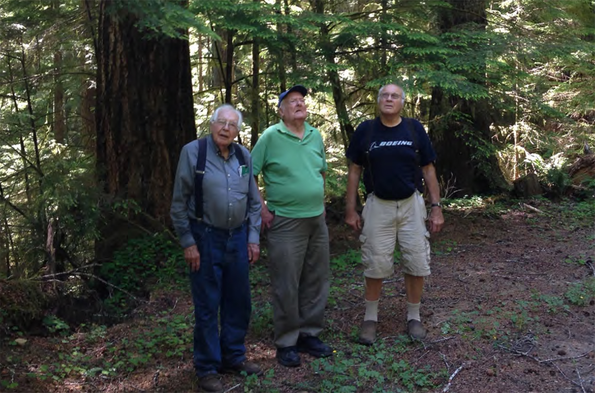
Fig. 1. Wayne Giesy, Jerry Phillips and David Gould, Jerry Phillips Reserve, Elliott State Forest, July 8, 2017 (Photo by Bob Zybach).
It is difficult doing a field trip without actually going into the field; or to do a group project or workshop without actually gathering as a group or working at a shop. The 2020 coronavirus pandemic caused some immediate and significant changes to spring-term plans that had been formalized just a few weeks earlier.
I have been working with Tasha Livingstone and her spring-term F251 Forest Recreation class for the past four years. The focus has been on student group projects related to recreational opportunities on nearby Elliott State Forest: the 2018 class produced the first draft recreation plan ever written for the Elliott (Kronsberg et al 2018) and the 2019 class reviewed and refined the draft plan (Etzwiler et al 2019).
Both classes participated in a series of either five (2019) or six (2018) four-hour field trips to the Elliott with local experts to witness and experience the topics they were learning about. All finished student work -- including documented field trips -- was put online as ORWW educational websites by both classes for the purposes of refining student Internet communication skills and for sharing with others -- especially future students -- interested in learning more about the Elliott and about forest recreation: www.orww.org/Elliott_Forest/Recreation.
The 2018 and 2019 students were consistent in their recommendations that road signs and better road maintenance were priority needs for any recreational or educational uses of the Elliott, and as a matter of public safety. A planning meeting was held at SWOCC on March 10, 2020 to discuss upcoming field trips and workshops for spring-term F251 students, beginning in April. Existing field trip routes, group project design, and lectures were decided to remain about the same as proven successful in previous years, but to shift the study focus to Elliott road and trail histories -- as recommended -- and to consider those relationships to current recreational opportunities and public access needs (Zybach 2019).
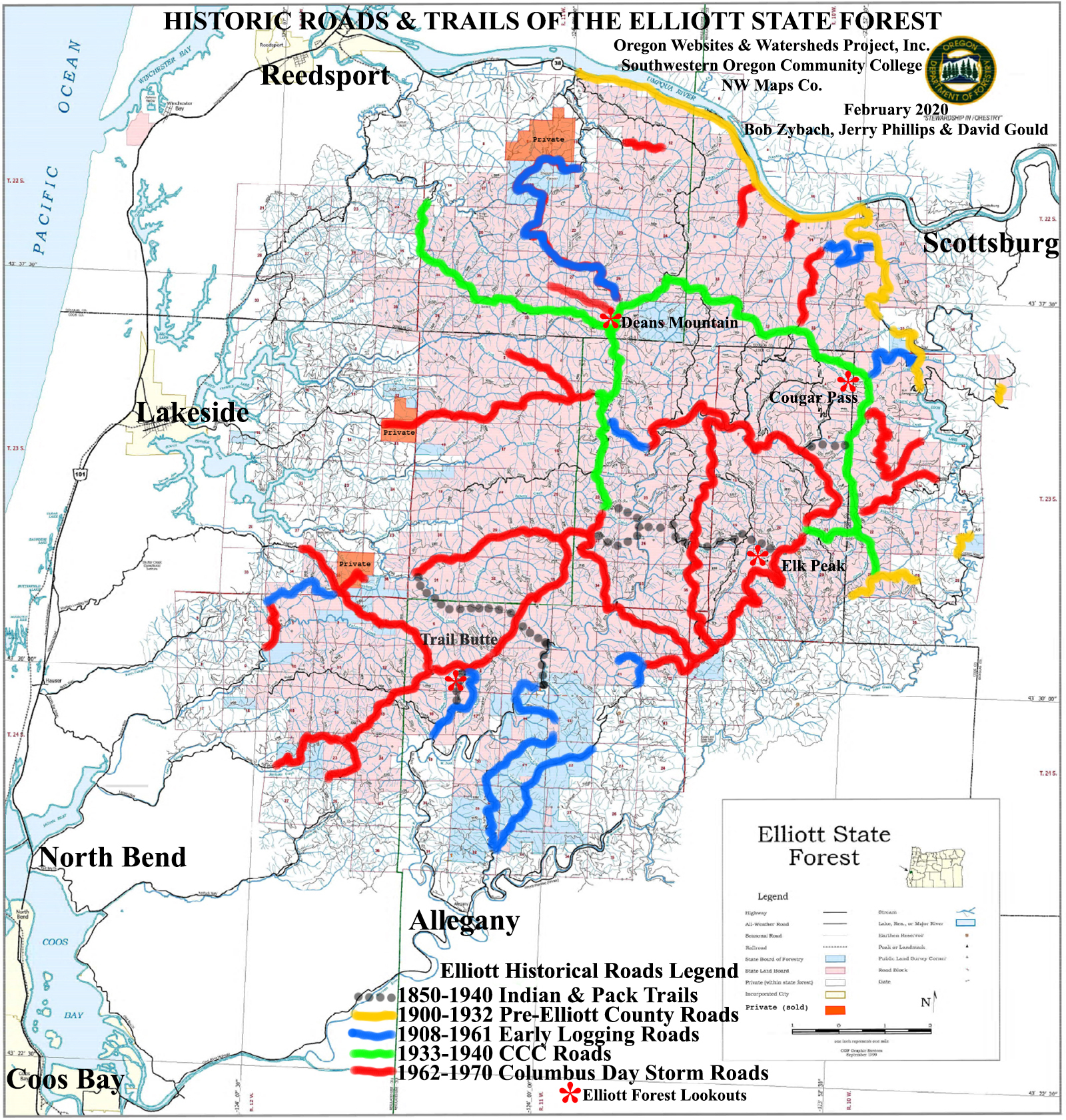
Map 1. Historic Roads & Trails of the Elliott State Forest (Oregon Department of Forestry Graphic Services 1999; Zybach, Phillips & Gould, February 2020).
A few expected planning people were suddenly absent at the March 10 meeting because of the rapidly emerging pandemic concerns and changing directives at that time. Then, before classes started in April, we were informed that students couldn't be in close proximity to one another (at least in a field trip van); then, shortly after, they couldn't assemble in classrooms, either -- at least for a few weeks; and then, all term. No direct physical contact, much less group projects, classroom lectures, or field trips possible. But they could still take the course online for required credit.
Quick decisions were made. Tasha implemented a community Google.doc file for students to use for collaborating, developing, and editing their work in concert with instructors. Everyone was theoretically learning together, but at different times, in different locations, using different computer equipment, and with different WiFi reception speeds -- many of us in rural locations -- and no one with direct technical, library, or field access. But at least we were all working on the same documents with mostly the same Word formatting -- itself a big improvement from previous years!
McKenzie Peters, NW Maps Co., and I began videotaping "distance learning" lectures as de facto ORWW workshops for the spring-term class with an Android phone and a tripod. These began with me against a wall with a map of the Elliott, or close-ups of the computer screen and were posted to the ORWWmedia YouTube channel for students to view. Online worksheets with links to the digitized videos, earlier SWOCC student photos and reports, oral histories, maps, articles, books, historical photos and other relevant research materials were posted on the ORWW Elliott Recreation website and distributed weekly to the students.
McKenzie also videotaped David Gould, Jerry Phillips, Nancy Stewart and me on five socially-distanced "virtual" field trips of the Elliott. These replicated the courses taken by the 2018 and 2019 classes, were directly linked to previous student work and ORWW Elliott content, and also posted on YouTube: https://www.youtube.com/playlist?list=PL1JyKCHg2GmHjLtQzXXDks4Rb-LE9HoJ-.
The field trip videos were also done with the Android, a tripod, and inexpensive editing software. No schools, libraries, archives, computer repair shops, or even public restrooms were open. There was no budget, advanced warning, good quality equipment, technical expertise, or even an available studio or classroom to work in. David's and Jerry's families were reasonably concerned about their health and risk of being in close proximity to people from the Willamette Valley during the field trips, but everything was somehow completed on time and with surprisingly few problems. Everyone also remained in good health and spirits.
As a result of the pandemic, the 2020 F251 students did not directly participate in field trips, take their own photos, ask direct questions, or take part in group discussions. Instead, they were forced to use photos and videos taken by McKenzie, myself, earlier students, and others working on these projects; and they needed to rely on the earlier observations, writings and reports of others, including local experts -- now, mostly strangers instead of mentors -- as well.
*****************
The ORWW 2020 SWOCC F251 educational project was designed to focus on the Elliott State Forest roads and trails and their historical significance in regard to current and future public access and recreational opportunities. "Historical significance" has important management and use implications that are regulated by state and federal laws (SHPO_2015). There are two basic definitions of "historical": 1) the record of time during which people have lived in a certain location; and 2) the existing written eyewitness accounts of people for a certain location.
People have lived within and around the current area of Elliot State Forest since "time immemorial" -- more than 10,000 years, at least. This record can be partly told with archaeological research, persistent vegetation patterns, and early historical documentation. A few precontact traditions also persist through family stories and oral histories. So long as people have lived near or within present-day Elliott there have been trails along the streams and ridgelines; with hunting, fishing, camping, and firewood gathering always being a major focus. At some point people began cultivating huckleberries, myrtle nuts, iris and other food and fiber plants along these routes. Butterflies, songbirds, deer, elk and bear quickly followed and populated these creations. This symbiotic relationship between people, fire, favored plants, and native animals likely existed for millennia before the first written records, and was well established and documented during early white immigration.
The documentary history of the Oregon Coast can be said to have generally started with sightings and contact by the James Cook expedition in 1778, or possibly with Francis Drake in 1579. Land-based records for the Elliott area, including written eyewitness accounts, maps, and drawings, began in 1826 with a Hudson Bay Company beaver trapping expedition led by Alexander Roderick McLeod (Davies 1961: 175-212). McLeod kept a detailed daily journal for business purposes and his trapping parties traveled through the area a number of times in the following two years. These visits culminated with a return trip in late 1828 with Jedediah Smith in order to recover valuables -- mostly horses and beaverskins, but also a map and written journal -- and bury the dead from the massacre that had taken place at the mouth of Smith River a few weeks earlier. Both McLeod and Smith kept daily journals (Sullivan 1934: 112-135).
The next historical record of note was a journal and correspondence of a two-day visit to the mouth of the Umpqua in 1840 by Methodist missionaries Gustavus Hines and Jason Lee (Hines 1887: 93-119). Then, in 1850 a ship sailed into the mouth of the Umpqua and white immigrants from San Francisco claimed 640 acres at the mouth of Mill Creek -- where they soon constructed a home, the namesake sawmill, a shipbuilding yard, and began paying taxes (Phillips 1998: 391-393).
The historical roads and trails and canoe routes of the Elliott State Forest and bordering lands and waters have directed its human history and native plant and animal populations for thousands of years, until now. A detailed written accounting of this landscape begins about 1850, but the actual history of the Elliott begins with its creation in 1930, only 90 years ago. The CCCs, World War II, logging, the Columbus Day Storm, hunting, fishing, political protests, illicit crops, mud-running, camping, reforestation, and the 1982 and 1996 floods and landslides have shaped much of its history since -- and all reflected in its roads and trails and their uses and potential uses today.
The following student reports, despite being written under unique circumstances and without the aid of first-hand observations or discussions, provide an excellent foundation of maps, facts, resources, and recommendations to build from: whether by future Elliott State Forest student visitors, researchers, recreationists, or forest managers. This work is intended to be combined with linked ORWW educational website content, videotaped "distance learning" lectures, and "virtual" field trips for a more complete and comprehensive understanding of the Elliott -- as developed for and by past and current SWOCC F251 students.
************************
NOTE: As this is being written in early June 2021, current F251 students are also limited by ongoing pandemic restrictions and can't meet in person, attend classes, or take field trips. However, the intervening year has allowed for more "distance learning" practice by everyone, the rapid development of Zoom communications, better video equipment and software, and the added uses of YouTube indexing and closed captioning for the videotaped 2020 field trips. These are still not ideal substitutes for actual field trips, group projects, or personal discussions, but good improvements for future Elliott "distance learning" educational products and their uses. The hope is that these uses will be complementary to actual meetings and field trips for future students, rather than act as substitutes.
![]()
© 2021 Oregon Websites & Watersheds Project, Inc. & NW Maps Co.