Early Historical Roads and Trails of Ancestral Coquille Indian Lands, 1826 - 1875

Battle Rock and Port Orford, Oregon Territory, in 1855 (Wells 1856: 590).
Coquelle Trails: Early Historical Roads and Trails of Ancestral Coquille Indian Lands, 1826 - 1875 renews a project originally started in 2006 to investigate and publish a “cultural geography” of the modern Coquille Indian Tribe: a description of the physical landscape and geographic area occupied or used by the Ancestors of the modern Coquille Tribe prior to -- and at the time of -- the earliest reported contacts with Europeans and Euro-American:
| "When Alexander McLeod first entered the country of Coos and Coquille people in 1826, he had arrived in a land almost completely unknown to the outside world, inhabited by people who spoke unknown languages and kept to themselves. There were no maps, written or verbal accounts, or even known landmarks -- excepting the seacoast -- for the entire region . . . In 1826 there were no pack trails or wheeled vehicles anywhere in the Coos or Coquille river basins, and never had been. Transportation was by foot or by canoe. A clear line of demarcation between these modes of travel was the head of tidewater in Coos Bay and its sloughs; in Coos River; and in Coquille River and its sloughs." |
January 7, 2013 Press Release [PDF_318_KB]
| Acknowledgements. The people & organizations who made this project possible. | |
| Introduction & Purpose. Coquelle Trails & the Coquille Tribe Cultural Geography Project. | |
Methodology: How the Maps Were Made. Illustrated research & product development process -- w/links to current products --including: reports, maps, databases, photographs, annotated bibliography, PDF reference library, etc. |
|
Rivers & Tidelands. UNDER CONSTRUCTION. Coos Bay; Coos River; Coquille River; Elk River; Floras Creek; Millicoma River; New River; Sixes River; Williams River. No estimated completion date. |
|
| Historical Districts, 1826 - 2012. Seven Historical Districts were developed for purposes of research, display & analysis: Allegany; Bandon; Bridge-Remote; Coos Bay; Fairview; Port Orford; South Fork. | |
| Historical Accounts, 1826 - 1875. Alexander McLeod, 1826; Jedediah Smith, 1828; Lt. Silas Casey, 1851; Randolph Trail, 1853; Coose Bay Company, 1853; Coos Bay Wagon Road, 1869 - 1875. | |
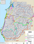 |
Maps, 1855 - 2012. Historical General Land Office (GLO) & USGS quadrangle maps played key research roles on this project: a series of 11 GIS-based maps that display research findings are a principal outcome. |
| Photographs, 2011 - 2012. UNDER CONSTRUCTION. There are nearly 3000 GPS-referenced documentary photos in process of being formatted, linked, & placed online. Estimated completion date: mid-2013. | |
| GLO Land Survey Notes, 1855 - 1934. Significant sampling of historical General Land Office field survey notes, w/links to relevant maps, a wide selection of daily journal entries & complete Reference List of GLO surveyors. | |
| Databases & Indexes, pre-1800 - 2012. These cross-referenced Excel, HTML & PDF index files & tables are the research & locational basis for documenting & referencing the Coquelle Trails report. | |
| References. Citable references used during this project, w/ PDF files & webpage links to several historical & scientific document reproductions & other relevant Reference lists. Includes an Annotated Bibliography for study area 1826 - 1900 time period. | |
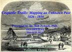 |
Presentation, 2012. Coquelle Trail project methods & findings presented at 65th Annual Northwest Anthropological Conference, March 15, 2012, Wildhorse Resort & Casino, Pendleton, Oregon. |
Zybach, Bob, 2012. The 1855-1856 Oregon Indian War in Coos County, Oregon: Eyewitnesses and Storytellers, March 27, 1855 – August 21, 1856. Unpublished report on file with the Coquelle Indian Tribe, North Bend, Oregon, and NW Maps Co., Cottage Grove, Oregon: 259 pp.
Zybach, Bob and Don Ivy 2013. Coquelle Trails: Early Historical Roads and Trails of Ancestral Coquille Indian Lands, 1826 - 1875 (2 vol.). Coquille Indian Tribe, Inc., North Bend, Oregon and Oregon Websites and Watersheds Project, Inc., Philomath, Oregon: 202 pp.